Micronesia: Yap, Chuuk, Ifaluk, and Pohnpei – Stone Money, Underwater Airplanes, and More

Central African Republic: Hunting with the Pygmies, Gorilla Love, and Other Stories (2009)
February 29, 2020
IRAN – Visit to the Axis of Evil, and Its Jews (2010)
July 7, 2020Micronesia: Yap, Chuuk, Ifaluk, and Pohnpei – Stone Money, Underwater Airplanes, and More
By Rich Juro
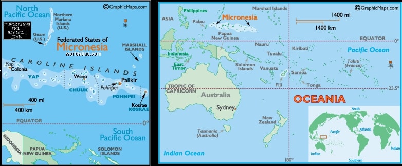
Micronesia is an island nation in the western Pacific, kind of between Japan and Australia. Ever since its independence from the USA, the full name has been Federated States of Micronesia (FSM). Our adventures in Micronesia consisted of two separate expedition sailings. First was the 1990’s trip from the island of Pohnpei to Chuuk and Ifaluk. The second was in 2013 from New Guinea, and we accidentally wound up in Yap. We’ll explain Yap (I love that name!) and “accidentally” later.
Pohnpei and an Ancient Enigma
First was Pohnpei, the largest island of FSM, and home to almost 40,000 people. When the country became independent from the USA in 1986, there was a Compact of Free Association signed, so Micronesians can freely come to the USA to work and live. We knew some Micronesians, as several worked for us in Omaha at our supermarkets. They were all good workers, and they were all short, squat, and medium brown skin color. Most of them had interesting names, like Charles Charley. On arrival, a customs inspector came on the ship. We weren’t worried because our long-term night crew manager, Hackett Smith, told us his brother was the customs guy. The official on the ship wasn’t Hackett’s brother, but when we went through immigration, we recognized a “double” for Hackett. It was his brother, we gave regards, he grinned, and passed us without inspection (not that we were carrying any contraband).
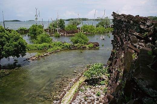
The capital of Micronesia is Palikir, and its on Pohnpei Island. But the real attraction was a seven square mile archaeological enigma called Nan Madol.
The US Park Service describes it: “The city ruins are on a coral reef, adjacent to the eastern shore of Pohnpei. Before its abandonment, Nan Madol was a major political and spiritual hub for native Pohnpeians. Throughout its 500 year life, from 1200 until 1700, the city served as a religious center, a royal enclave, a fortress, an urban marketplace, and the high seat of government for the island of Pohnpei.
“During its height Nan Madol was the seat of the Saudeleur dynasty which united all of Pohnpei’s estimated 25,000 people… According to Pohnpeian oral history, the first Saudeleur to arrive on Pohnpei were two brothers, canoe-faring sorcerers who received their powers from the gods and used their magic to build Nan Madol. This so impressed the native Pohnpeians that they invited the Saudeleur to marry into their tribe. When one of the brothers eventually died, the other declared himself king.”
Eventually, in the year 1628, people came from a nearby island, joined with the oppressed people, and overthrew the dynasty. The splendor of Nan Madol was soon abandoned.
When we went to Nan Madol, it was raining hard as it usually is in Pohnpei (it gets about 20 feet of rain a year). It was all we could do to scramble over the boulders and avoid falling into the ocean canals. We remember being impressed by the big stone buildings, but now you know the legend and the history of the place as well as us.
Chuuk – Ocean Graveyard of Armaments
First, a little history. The big Oceanic area of 600 islands of Micronesia (of which FSM is only part) was first settled by Melanesians (from Vanuatu) 4,000 years ago. Then Indonesians, Filipinos, and Polynesians arrived over the centuries, creating a new people called Micronesians.
Spanish explorers first “discovered” it in the 16th century, and named it the Caroline Islands after King Charles II. In spite of incidents where the natives massacred the Catholic priests, Spain later colonized it. In 1899, Germany bought the Caroline Islands from Spain. During WW I Japan became the administrator, with the US having commercial rights. Japan built a huge naval base in Chuuk (then called Truk). After WW II, the USA became the administrator for the United Nations Trust Territory of the Pacific Islands. Guam and the Northern Marianas still are USA territories. Eventually, FSM, Palau, and the Marshall Islands became separate independent nations. As mentioned above, the Compact of Free Association gives the right for islanders to go to the USA to live and work, and the USA gives aid and handles security and defense.
Because Truk had a coral atoll that created a safe harbor, the Japanese military built it up as a combined fleet harbor before WW II. It was also a good location for supplying and importing goods from their “Southern Sector”. Eventually, Truk became known as the “Gibraltar of the Pacific”. By 1944, the war had turned, and Japan began moving ships from Truk to further west. Nevertheless, the US military launched “Operation Hailstone” on February 17-18, 1944. Hundreds of ships and planes attacked Truk. 6000 Japanese army or sailors were killed, and 250 Japanese warplanes and 40 ships were destroyed, either still on base or flying or sailing.

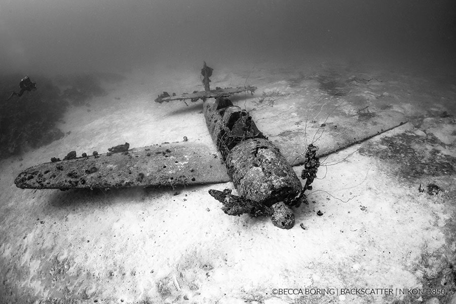
As these photos show, today Chuuk is known as the best place in the world to scuba or snorkel to see WW II military equipment underwater. I don’t dive, just snorkel, so the crystal clear water enabled me to see the ships and planes just 50 feet below the surface. Now reefs are forming, so you can see anemones and schools of fish in the ships. It was fascinating to view the biggest graveyard of ships in the world.
Ifaluk – Preserving (Some) Native Culture
Ifaluk (also spelled Ifalik) is an isolated atoll of 4 tiny islands in the middle of FSM. There are no roads, no vehicles, and no electricity. Its so isolated that it kept its own native religion until after WW II when a couple of missionaries arrived.
Four elderly chiefs make decisions for Ifaluk. They are very concerned that the people are losing their culture. So a while before we came, the chiefs promulgated the following rules to keep their traditions alive and well:
1) Outboard motors were banned so that men would keep fishing in their traditional outrigger canoes that were carved from breadfruit trees and sailed under the ancient navigational methods;
2) The women were prohibited from wearing tops.
Usually the chiefs are not questioned in their rules. But the men of Ifaluk protested so much about the ban on outboard motors that the chiefs rescinded the proclamation. However, the ban on tops for women stayed.
When we got onshore we were treated to a traditional dance performed by men, women, and children. Then we wandered around the island. I went to where the men and boys were constructing and sailing the outrigger canoes. A couple of women tourists went to the women’s enclave.

Ifaluk young dancer
Fran instead looked at the local carvings and cloths to buy. Finally, she settled on one vendor: a fine looking, well-endowed, bare-breasted young woman, and bought a few items from her. I have the picture to prove it, but that one can’t be reprinted here. You might wonder, did Fran and the women tourists have to go topless in view (pun intended) of the chiefs’ rule? Well, no, the chiefs gave them a special dispensation.
What’s the future for Ifaluk? Unfortunately, not good. Its a coral atoll where the highest point is only a few feet above sea level. The global climate change is causing higher tides and the whole level of the Pacific Ocean is rising. So Ifaluk is in danger of the fresh water becoming brackish. Worse, unless climate change is stilled, the whole island may have to be evacuated in 20 years or so when the seas cover the island. The people, and the traditions, will be lost.
On the Way to Yap: Medical Emergency (not ours)
In 2013 we took another expedition ship in Oceania. It was supposed to go from New Guinea, visit several primitive islands east of New Guinea, then head to some islands of the FSM including Ifaluk, finally winding up in Palau (where I went swimming with jellyfish). But that’s for another story…
What happened is that after we left New Ireland (a remote island of New Guinea), an older lady tripped, fell down a flight of stairs, and fractured or broke her hip. We had a doctor on board, but he didn’t have the training or the equipment to do orthopedic surgery. The ship wasn’t big enough for a helicopter, and the islands we were heading for didn’t have a big landing strip. Plus, the lady was a caretaker for her husband. In this medical emergency, the captain and the doctor decided to change course, and headed for the island of Yap. There’s no real hospital on the island of Yap, but it has regular air service, and the injured could head for Manila in the Philippines. The doctor knew they could get good treatment in Manila, and the couple’s son was flying out from the USA.
Most of the passengers were unhappy but understood why we changed destinations. Fran and I were actually glad about it, because we had been to Ifaluk but not to Yap.
Yap: Trying to Get Stone Money
Yap is the main island of the Yap Islands at the western edge of the country of the Federated States of Micronesia. It has kept the most traditions alive. For example, no matter what you think of it, in the 20th century women were kidnapped and taken to the men’s house. Actually, it was considered an honor to be so selected, as only the most attractive women were kidnapped.
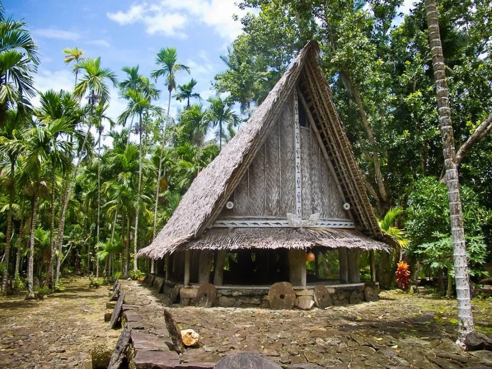
Some of the men’s houses still exist, along with the distinctive architecture of the big wooden and thatch tribal meeting houses (you can see one in the background of the picture).
A tradition that is dying is the caste system. Tribes who conquered another village then placed the new “subjects” in seven different castes. Body-filling tattoos used to be common, but not now. Skilled builders of the canoes and navigators are becoming rare. To guide them on long water journeys, Yapese used to use the waves, tides and the celestial compass of 32 stars. Now they use a GPS.
One tradition that is thriving is dancing. Dances by men, women, kids, or any combination are being maintained both for the enjoyment of Yap people and tourists. Stories are told by dances, whether of canoe-building, conquests, or religious events.
Finally, unique money is still here. Yap, as part of FSM, uses the US dollar as regular currency, but there are four other types of exchange possible:
1) Reng is ground tumeric, shaped like a ball;
2) Mmbul is the length and width of a lava lava, the loincloths worn by men (also by our son, Kevin, who got his knee-length lava lava in Fiji and wears it to dressy events);
3) Gaw or yar are necklaces of shells, more valuable if they came from other islands, and most valuable if they also include whale teeth;
4) The big, round, stone money is piled up around private houses and village centers. Each can be as big as 12 feet in diameter. Starting 2000 years ago, the Yapese used to carve and collect these crystalline calcite pieces from other islands. They primarily got these from Palau, over 250 miles each way. Imagine the long trip over the ocean in canoes, then carving limestone in the quarries of Palau, then taking them back for 250 miles in huge canoes or by towing rafts. No wonder they were considered valuable and became the main currency!
The stone money was also available in small denominations, as small as 1 ½ inch diameters. Yap is the only place in the world using stone money. I was going to pay for a dinner or for souvenirs using stone money, but there was none available. I guess I’ll stick to Fran’s tradition: credit cards.